

Round goby in the Seine: turning sightings into monitoring
Round goby has been documented in the Seine basin for years. Reports of abundant catches deserve attention, but assessing local population change and ecological effects requires verified identification and comparable surveys.
- Content type
- Practical guide
- Sector
- Environment
- Animal group
- Fish
- Keywords
- TransportBiosecurityTemperature
Keep the Seine chronology clear
Round goby, Neogobius melanostomus, originates from the Ponto-Caspian region. Its presence in the Seine is not a new discovery in 2026. The Seine-Normandy fish observatory describes a report from the port of Rouen in 2015, followed by local surveys. This chronology matters because renewed public attention is not the same event as the start of colonisation.
An angler’s observation can initiate useful monitoring. It cannot, on its own, quantify abundance throughout a river. When a species becomes conspicuous in catches, the next questions concern location, identification and how the observations were collected. Those details are needed before describing a basin-wide increase or attributing the disappearance of other fish to the newcomer.
Confirm the species before counting records
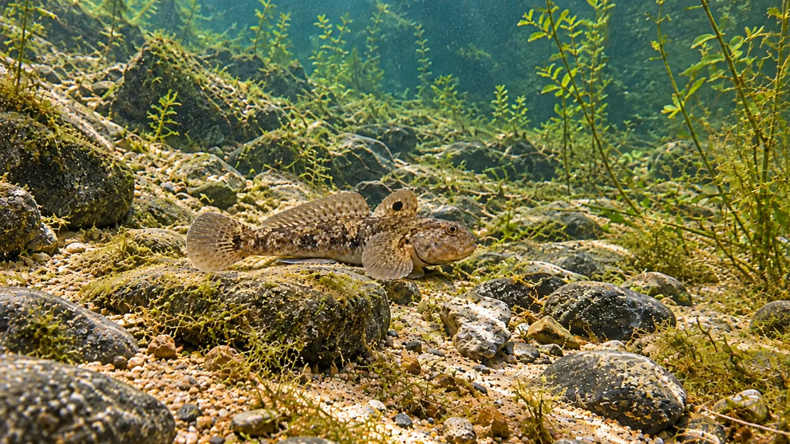
The observatory’s species account describes two dorsal fins, a dark spot on the first dorsal and pelvic fins joined to form a suction disc. These features help distinguish round goby from other small bottom-associated fish. A clear side photograph, supported where possible by views of identifying features, can assist confirmation by a competent local contact.
Its association with the bottom also affects interpretation. An observation from rocky margins does not necessarily describe conditions in a vegetated backwater or another reach. Records should retain an exact location, date and known circumstances. Without that context, several accurate sightings can still be difficult to use in a monitoring programme.
Build comparisons around survey effort
Following the initial report, the observatory describes electrofishing surveys in Rouen harbour. Its account reports an increase in captures between 2015 and 2017 in the same area using the same protocol. That offers stronger evidence of local change than a sequence of unlocated impressions. It nevertheless concerns a particular site and period, not the entire Seine basin in 2026.
Sampling results need information about effort: the area or time covered, equipment, season, accessible habitats and water conditions. A larger total catch can accompany more intensive searching. If methods change, that change should be recorded rather than treating all counts as one continuous, directly comparable series. Consistent recording is necessary even when the purpose is an initial assessment rather than a long-term population estimate.
Separate detection from ecological impact
An introduced species occurs outside its original range following introduction. Detecting it does not by itself quantify its effect on a local fish community. Round goby can consume invertebrates and interact with other bottom-associated fishes. Demonstrating an effect in a particular reach requires evidence concerning those communities and their changes, rather than a general account of the species’ potential impacts.
Habitat therefore remains part of the assessment. Rocky banks, port environments and connections between water bodies influence both establishment opportunities and where people observe the fish. Temperature can be recorded as environmental context. It should not become the sole explanation for increasing catches or community change without an analysis capable of testing that explanation.
Discuss dispersal without assigning an unsupported cause
Navigation and connected waterways feature in the dispersal pathways discussed by the observatory. Its account includes transport associated with boats as well as active or passive movements at different life stages. A plausible pathway at a general level does not identify the vessel or event responsible for a particular local introduction.
That distinction still allows practical prevention. Managers can examine avoidable transfers without making unsupported claims about responsibility. Moving fish, water or equipment between sites deserves attention during routine management and conservation work. An operation intended to benefit native fauna should not inadvertently create another opportunity for dispersal.
Make a sighting useful to the monitoring team
A usable report combines verifiable identification with location, date, number observed and the way the observation was obtained. Photographs should remain attached to this information. If several people report one event, combining the accounts avoids counting the same animals repeatedly. Uncertain identification should also remain visible until it is resolved.
Local angling federations and monitoring organisations can advise on the information required and how to submit it. Asking for those instructions is preferable to moving live animals for identification. Field biosecurity includes equipment and the water associated with an operation, as well as the animals being handled. These are practical considerations for the activity being planned, not evidence that every item is contaminated.
Managers can also distinguish routinely surveyed locations from occasional sightings. Failure to catch the species in a limited survey is not proof that it is absent. Conversely, a visible aggregation near a popular access point cannot be used to assign a density to the whole river. A monitoring map should preserve those differences rather than presenting every record as equivalent evidence.
Use concern to improve the evidence
Round goby warrants attention in the Seine, but conclusions should remain proportionate to the observations. Presence, local population change and a demonstrated ecological effect are different findings. Keeping them separate makes communication among anglers, local authorities and scientists more useful and reduces the risk of an unsupported explanation taking the place of monitoring.
Historical surveys can guide the questions asked today without being presented as current measurements. New records are most valuable when they can be connected to that history through location and method. The aim is to establish what has changed and where management can act, rather than promise a basin-wide population estimate from scattered reports.
Our consultancy and support service can help aquatic environmental managers structure observations and review transfer risks during field operations. This supports a documented monitoring plan without promising eradication or assigning an unproven cause.


